
Find Where This GeoGuessr Screenshot Was Taken
Get the most likely location with country, region, city, confidence score, and supporting evidence.
Upload a Geoguessr screenshot to find where it was taken.
Drop your photo here
or click to upload
JPG, PNG, WEBP, HEIC • Max 10MB
Not sure what to upload? Try one of these:
- AI-Powered Geolocation
- Evidence-Based Reasoning
- No GPS Required
Why Use an AI GeoGuessr Image Solver?
Upload a GeoGuessr screenshot and let AI analyze roads, signs, landscapes, architecture, and other geographic clues to estimate the most likely location. Instead of only providing a guess, AI explains the evidence behind each prediction to help you understand and improve your GeoGuessr skills.
Identify Countries and Regions
Analyze road signs, languages, road systems, driving patterns, and regional clues to identify possible countries and locations faster.
Identify Countries Faster
Recognize road systems, languages, signs, and regional patterns.
Narrow Down Locations
Combine architecture, urban layouts, terrain, landmarks, and visual patterns to move from broad guesses to more specific areas.
Find Hidden Geographic Clues
Discover subtle details such as road markings, vegetation, infrastructure, and regional patterns that are easy to overlook.
Understand AI Reasoning
See the evidence behind each prediction instead of receiving only a location guess.
Improve GeoGuessr Skills
Review rounds, learn geographic patterns, and improve your ability to recognize countries and regions.
How AI Analyzes GeoGuessr Screenshots
AI examines multiple geographic clues in a GeoGuessr screenshot, combining road systems, signs, architecture, landscapes, and regional patterns to estimate the most likely location.
Road Signs & Driving Patterns
Road signs, road markings, driving sides, traffic systems, and highway symbols provide strong clues for identifying countries and regions.
Language & Regional Indicators
Street names, advertisements, scripts, and local languages can reveal country-specific and regional clues.
Architecture & Urban Environment
Building styles, materials, roof designs, city layouts, and infrastructure patterns help narrow down possible locations.
Landscape & Natural Environment
Vegetation, terrain, climate, mountains, coastlines, and natural features provide clues about the region and environment.
Landmarks & Unique Geographic Features
Recognizable landmarks, unique terrain, and distinctive geographic features can provide strong evidence for specific locations.
Tips for Better GeoGuessr Screenshot Analysis
Follow these tips to provide better screenshots and help AI identify useful geographic clues during GeoGuessr analysis.
Upload the Full Screenshot
Keep the complete GeoGuessr screenshot whenever possible. Important clues such as road signs, minimaps, road markings, and surrounding scenery may help AI identify the location.
Use a Clear Image
Higher-quality screenshots provide more visible details, helping AI analyze signs, text, architecture, and environmental features.
Include Surrounding Clues
Avoid excessive cropping. Roads, buildings, vegetation, terrain, and distant landscapes often contain valuable geographic information.
GeoGuessr AI Solver Examples
See real GeoGuessr screenshot analyses and learn how AI combines multiple clues to estimate the most likely location.
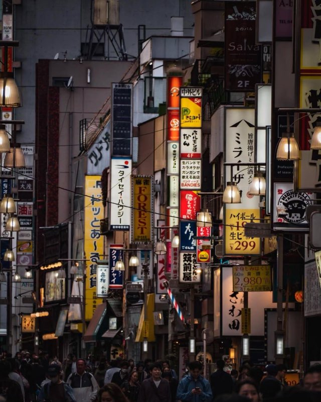
Tokyo, Japan
Key Location Clues
- Japanese Script
- Vertical Signage Density
- Highball Price Sign

Dhaka Division, Bangladesh
Key Location Clues
- Jatiya Sangsad Bhaban
- National Flag
- Clothing
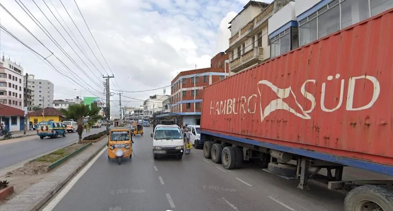
Dar es Salaam Region, Tanzania
Key Location Clues
- Hamburg Süd Container
- Tuk-tuks (Bajajis)
- Urban Buildings
How AI Helps You Improve at GeoGuessr
Use AI as a learning assistant to review GeoGuessr rounds, understand geographic clues, and improve your ability to recognize locations.
Clue analysis
Without AI Assistance
Analyze every clue manually
With AI Assistance
Review important geographic clues faster
Regional signals
Without AI Assistance
Miss subtle regional signals
With AI Assistance
Discover overlooked visual patterns
Research time
Without AI Assistance
Spend more time researching
With AI Assistance
Get instant location insights
Learning
Without AI Assistance
Learn only from personal experience
With AI Assistance
Explore AI-supported geographic reasoning
| Without AI Assistance | With AI Assistance | |
|---|---|---|
| Clue analysis | Analyze every clue manually | Review important geographic clues faster |
| Regional signals | Miss subtle regional signals | Discover overlooked visual patterns |
| Research time | Spend more time researching | Get instant location insights |
| Learning | Learn only from personal experience | Explore AI-supported geographic reasoning |
Frequently Asked Questions
Explore Related Resources
Discover more AI-powered tools and guides to identify photo locations, recognize landmarks, read EXIF metadata, check geotags, and solve GeoGuessr screenshots.
Find Location from Photo
Upload a photo or screenshot and let AI analyze visual clues to estimate where it was taken without GPS metadata.
Try ToolIdentify Landmarks from Photos with AI
Upload a photo to recognize landmarks, buildings, monuments, and famous places with AI location analysis.
Try ToolReverse Image Search vs AI Image Location Finder
Compare reverse image search and AI geolocation to understand how photos can be identified with or without online image matches.
Learn MoreWhere Was This Photo Taken?
Discover where a photo was taken with AI by analyzing landmarks, architecture, roads, landscapes, and other geographic clues.
Learn More
Analyze Your Next GeoGuessr Screenshot
Upload a GeoGuessr screenshot and let AI analyze geographic clues to estimate the most likely location with supporting evidence.