
Find Location from Any Photo
Upload a photo, image, or picture and use our AI photo location finder to discover where it was taken. Our AI analyzes landmarks, buildings, roads, text, and surroundings to estimate the location without GPS metadata.
Drop your photo here
or click to upload
JPG, PNG, WEBP, HEIC • Max 10MB
Not sure what to upload? Try one of these:
- AI-Powered Geolocation
- Evidence-Based Reasoning
- No GPS Required
How AI Finds a Location from a Photo
AI image geolocation analyzes visual clues inside your photo, compares geographic patterns, and estimates the most likely location with supporting evidence.
1. Upload Your Image
Upload a photo, screenshot, or GeoGuessr round to start the AI location analysis.
2. Analyze Visual & Geographic Clues
AI analyzes landmarks, architecture, roads, signs, landscapes, and environmental details to identify geographic patterns.
3. Determine the Most Likely Location
AI uses geographic context and patterns to estimate the most likely country, region, or city.
4. Explore the Location Evidence
View the predicted location with confidence score, map, and the evidence behind the prediction.
What Your Photo Location Result Include?
Estimated Location
Find the most likely country, region, and city where your photo was taken.
Interactive Map
Explore the estimated location visually on an interactive map.
Confidence Score
Understand how reliable the AI prediction is based on available geographic clues.
Geographic Evidence
See the visual clues that influenced the location estimate, including landmarks, buildings, architecture, roads, vegetation, terrain and other clues.
Alternative Locations
Review other possible locations considered during AI analysis.
Photo Location Analysis Examples
See how our AI photo location finder analyzes different types of photos and estimates where they were taken.
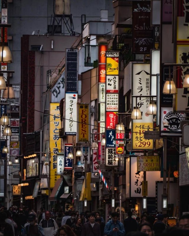
Tokyo, Japan
Key Location Clues
- Japanese Script
- Vertical Signage Density
- Highball Price Sign
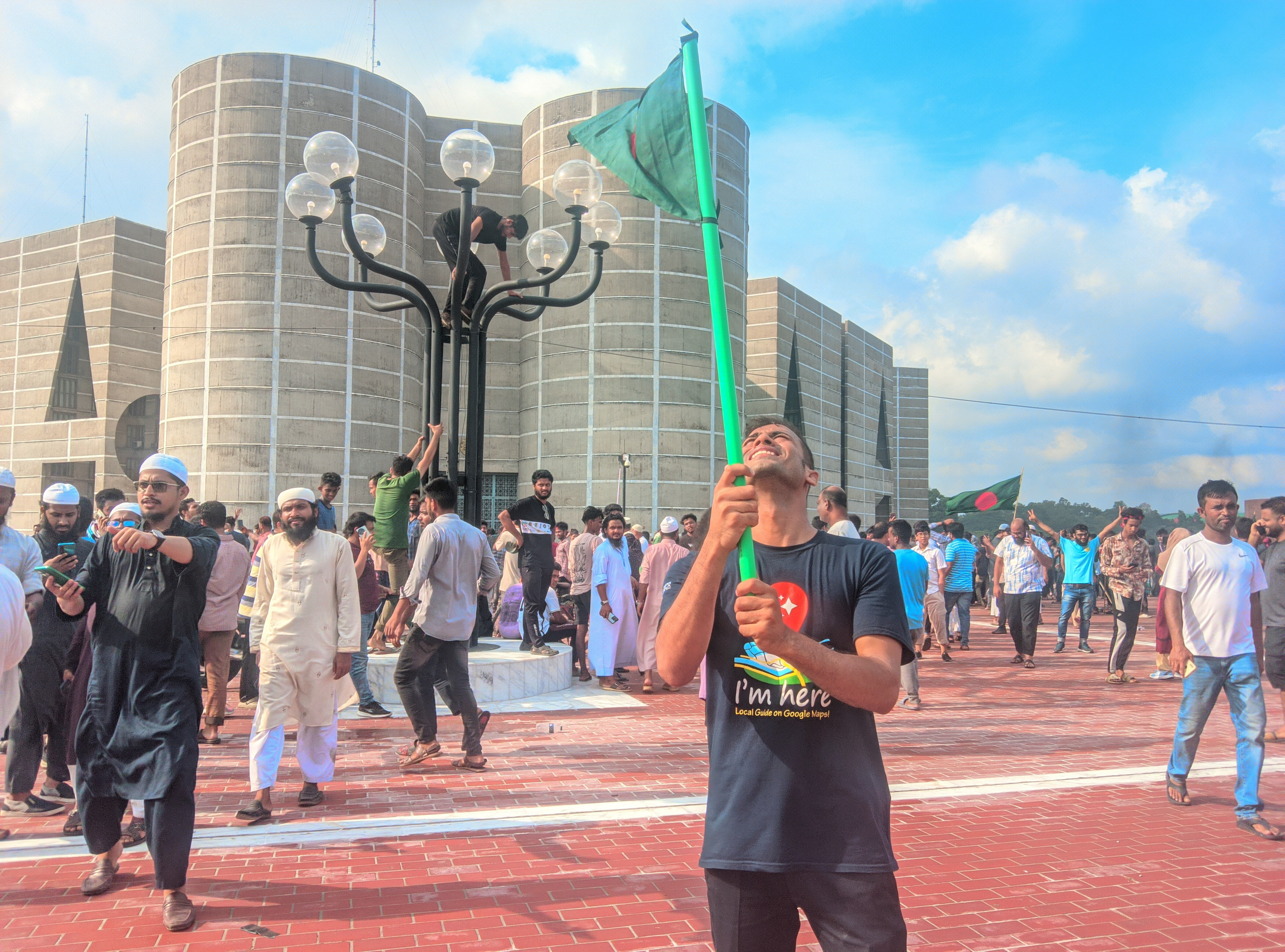
Dhaka Division, Bangladesh
Key Location Clues
- Jatiya Sangsad Bhaban
- National Flag
- Clothing
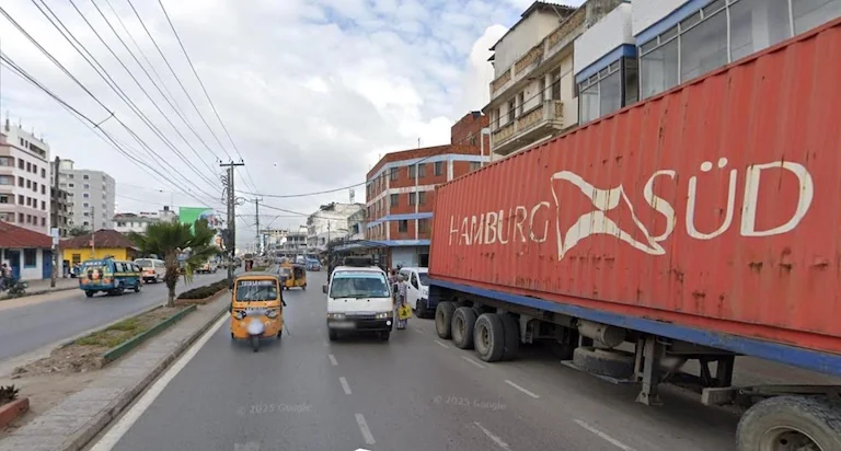
Dar es Salaam Region, Tanzania
Key Location Clues
- Hamburg Süd Container
- Tuk-tuks (Bajajis)
- Urban Buildings
What Images Can You Analyze?
Our AI image location finder can analyze many types of photos and images, including travel pictures, street scenes, screenshots, and historical photos.
Travel Photos
Identify possible locations from vacation photos, city views, and destination images.
Street Scenes
Analyze roads, buildings, signs, vehicles, and urban environments.
GeoGuessr Screenshots
Use AI geographic analysis to estimate locations from Street View and game screenshots.
Landscape Images
Explore possible locations from mountains, coastlines, forests, and natural environments.
Historical & Scanned Photos
Analyze older images by examining visible buildings, surroundings, and geographic clues.
Social Media Images
Estimate locations from images shared on social platforms.
What Affects Photo Location Accuracy?
Photo location accuracy depends on the amount, quality, and uniqueness of the geographic clues visible in an image. Photos with clear environmental details can provide stronger signals, while images with limited context may produce lower-confidence location estimates.
Images With Strong Geographic Clues
Images containing distinctive geographic clues usually allow AI to make more accurate location estimates. These clues provide information about the environment, culture, infrastructure, and natural features visible in the image.
Clear Landmarks
Famous landmarks and recognizable structures provide some of the strongest location signals because they are directly associated with specific places. Examples include historical buildings, monuments, bridges, towers, religious sites, and famous attractions. AI can compare recognizable visual features such as shape, design, surrounding environment, and architectural details to identify possible locations.
Street Scenes With Visible Details
Street-level images often contain many small geographic clues that reveal where a photo was taken. Examples include road signs, street names, storefronts, traffic signs, lane markings, public transportation, and vehicles. Infrastructure, driving patterns, languages, and urban layouts often vary between countries and regions.
Distinctive Architecture
Buildings and urban design can reveal geographic patterns associated with specific regions and cities. Examples include traditional houses, building materials, roof styles, window designs, urban density, and historical architecture. Architectural styles often reflect local climate, culture, history, and construction practices.
Natural Landscapes
Outdoor environments provide valuable clues through geography, climate, and ecology. Examples include mountains, coastlines, forests, deserts, lakes, rivers, and vegetation. Terrain, weather patterns, and plant life can narrow down possible geographic regions.
Text and Language Clues
Visible text is one of the most powerful geographic signals when available. Examples include road signs, store names, advertisements, public notices, and street signs. Languages, scripts, and local naming patterns can quickly narrow down countries and regions.
Vehicles and Road Infrastructure
Transportation details often reveal regional differences. Examples include license plates, vehicle models, road markings, traffic lights, and driving side. Traffic systems and vehicle patterns vary significantly between locations.
Images With Limited Geographic Clues
Some images contain fewer visible geographic clues, making it harder for AI to determine an exact location. These images can still be analyzed, but the estimated location may have lower confidence or only identify a broader region.
Indoor Photos
Indoor environments usually contain limited geographic information because they often lack outdoor features such as streets, landscapes, architecture, or regional infrastructure. Examples include rooms, offices, restaurants, museums, and hotels.
Close-up Portraits
Portraits focused mainly on people usually provide fewer location clues unless the background contains recognizable landmarks, buildings, signs, or environmental details. Examples include selfies, profile photos, and close-up faces.
Night Images
Low-light conditions can hide important visual details such as road signs, building styles, vegetation, and surrounding environments. Challenges include reduced visibility, missing architectural details, and less readable text.
Heavy Filters or Edited Images
Strong filters, color adjustments, or image edits may change important visual characteristics and make geographic analysis less reliable. Examples include social media filters, artificial color grading, and extreme contrast adjustments.
Blurry or Out-of-focus Photos
Blurry images may hide critical clues such as text, signs, license plates, building details, and road markings. Challenges include unclear objects, missing small details, and reduced visual comparison accuracy.
Low-resolution Images
Small or compressed images may not contain enough detail for AI to identify important geographic signals. Examples include old compressed photos, screenshots with poor quality, and highly resized images.
Images With Very Little Background
Photos showing only a single object often provide limited context. Without surrounding buildings, landscapes, or environmental patterns, location estimation becomes more difficult. Examples include close-up objects, food photos, product photos, and isolated items.
Generic Urban Scenes
Ordinary streets without readable signs, unique architecture, or distinctive features may look similar across many locations, making precise identification more challenging. Examples include residential streets, empty roads, and common buildings.
Tips for Better Result
To improve AI location estimation accuracy, upload images that contain as many visible geographic clues as possible. More context, higher quality, and clearer details help the AI identify potential locations more reliably.
Include More Background Context
Photos with surrounding environments usually provide more location clues than tightly cropped images. Include streets, buildings, landscapes, or surroundings; avoid cropping out important background details; and capture the relationship between objects and their environment.
Upload Higher-quality Images
Clearer images allow AI to analyze smaller details such as signs, architecture, road markings, and textures. Use original photos when possible, avoid heavily compressed images, and upload the highest resolution version available.
Keep Text and Signs Visible
Text-based clues can provide some of the strongest geographic signals. Keep road signs readable, include storefront names, avoid covering important text, and upload images where local language is visible.
Include Distinctive Features
Unique landmarks, architecture, and natural features make it easier to narrow down possible locations. Look for famous buildings, bridges, monuments, mountains, coastlines, and unique streets.
When to Use an AI Image Location Finder?
An AI image location finder can help identify where photos were taken in many situations, from discovering travel destinations to analyzing street scenes, historical images, and GeoGuessr screenshots.
Discover Where a Travel Photo Was Taken
Found a beautiful destination online or in your photo library? Upload the image to estimate where it was captured and explore new places.
Improve Your GeoGuessr Skills
Analyze GeoGuessr screenshots and Street View images to identify countries, regions, cities, and geographic clues that help improve your location guessing skills.
Find Locations From Old or Historical Photos
Explore the possible locations of old family photos, archived images, or historical pictures by analyzing buildings, landscapes, signs, and other visible clues.
Verify Locations From Social Media Images
Check where images from social platforms may have been taken by analyzing visible landmarks, environments, and geographic details.
Identify Landmarks and Natural Locations
Discover possible locations of famous landmarks, mountains, coastlines, forests, and other natural environments from a single image.
Analyze Images for Research and Education
Researchers, journalists, and educators can use AI image geolocation to investigate visual information, study places, and understand geographic context.
Why Choose Our AI Image Location Finder?
Unlike traditional location lookup tools that rely on GPS metadata or existing databases, Our AI image location finder helps you get image location information from visual clues, even without GPS metadata. It combines computer vision, geographic reasoning, and location evidence to provide a deeper understanding of each image.
Find Locations Without GPS Metadata
Many photos lose GPS information when shared online. Our AI can estimate locations by analyzing visible clues inside the image instead of relying on hidden metadata.
AI Image Geolocation Technology
The system analyzes multiple geographic signals including landmarks, architecture, roads, text, vegetation, terrain, and environmental patterns to identify possible locations.
Understand Why a Location Was Suggested
Get more than a location guess. Each analysis includes supporting evidence that explains which visual clues influenced the result.
Works With Real-world Images
Analyze more than just famous landmarks. The AI can evaluate travel photos, street scenes, landscapes, GeoGuessr screenshots, historical images, and social media pictures.
Built for Exploration and Discovery
Discover unknown places, verify image locations, practice GeoGuessr, research photos, or explore destinations from a single image.
Frequently Asked Questions
Explore Related Resources
Discover more AI-powered tools and guides to identify photo locations, recognize landmarks, read EXIF metadata, check geotags, and solve GeoGuessr screenshots.
EXIF Data Viewer
View EXIF data from photos online. Extract camera settings, lens information, ISO, aperture, shutter speed, and GPS location.
Try ToolRemove Image Metadata
Remove EXIF, GPS, camera details, timestamps, and other hidden metadata from photos before sharing online.
Try ToolGeoGuessr Image Solver
Analyze GeoGuessr screenshots with AI and identify possible locations using roads, signs, landscapes, and geographic clues.
Try ToolReverse Image Search vs AI Image Location Finder
Compare reverse image search and AI geolocation to understand how photos can be identified with or without online image matches.
Learn More
Ready to Find Location from Your Photo?
Start using our AI photo location finder to identify where any image was taken.